
Updated Winter Storm Warning Calling For Snow
Updated Winter Storm Warning
WINTER STORM WARNING IN EFFECT FROM 6 AM SATURDAY TO NOON CST MONDAY FOR THE FOLLOWING COUNTIES AND CITIES;
Counties of Llano-Burnet-Williamson-Val Verde-Edwards-Real-Kerr-Bandera-Gillespie-Kendall-Blanco-Hays-Travis-Bastrop-Lee-Comal-Caldwell
Including the cities of Llano, Burnet, Georgetown, Del Rio, Rocksprings, Leakey, Kerrville, Bandera, Fredericksburg, Boerne, Blanco, San Marcos, Austin, Bastrop, Giddings, New Braunfels, and Lockhart
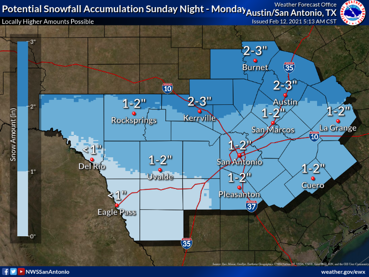
MONDAY FORECAST
• From 6 AM Saturday to noon CST Monday and forecasted to happen from North of a Del Rio
…to New Braunfels to Giddings line.
Light icing accumulations will be possible Saturday and any icing on already frozen surfaces will quickly become problematic.
A more robust system will arrive Sunday afternoon and Sunday night and bring total snow accumulations of 1 to 3 inches and ice accumulations of around one tenth of an inch.
* ADDITIONAL DETAILS…
In addition to the wintry precipitation, temperatures will drop into the single digits and teens Sunday night with wind chills near zero. These temperatures can lead to hypothermia for anyone stranded within the icy roads expected.

* PRECAUTIONARY/PREPAREDNESS ACTIONS…
If you must travel, keep an extra flashlight, food, and water in your vehicle in case of an emergency. The latest road conditions for the state can be obtained at drivetexas.org.


