
San Marcos CIP Projects In Design Phase Total $91.6 Million
![]() The City of San Marcos has 32 Capital Improvements Projects in the design process currently scheduled to happen between summer 2018 and 2022with a total of $91,676,932 …
The City of San Marcos has 32 Capital Improvements Projects in the design process currently scheduled to happen between summer 2018 and 2022with a total of $91,676,932 …
![]()
The City of San Marcos has 32 Capital Improvements Projects in the design process currently scheduled to happen between summer 2018 and 2022 with a total of $91,676,932 million. The projects have been identified by the city’s engineering department as high priority.
The goal is aimed at improving areas that could be potentially hazardous in the future or areas of potentially growth in the future. Some of the projects include improvements to help prevent future floods or repair damage caused by past floods.![]()
Can’t see the whole table? Touch it and scroll right.
| PROJECT NAME | CONSTRUCTION COST (Estimated until under contract) | CITY PROJECT MANAGER |
DESIGN FIRM |
ANTICIPATED PROJECT START DATE |
|---|---|---|---|---|
| Bishop Street Improvements | $5,500,000 | Shaun Condor | Cobb Fendley | 2020 |
| Blanco Gardens Drainage Improvements | $4,700,000 | Rey Garcia | Scheibe Consulting | Summer 2019 |
| Blanco River Waterline Bore Improvements | $600,000 | Kirk Abbott | K. Friese & Associates | Fall 2018 |
| Blanco Riverine Project | $2,000,000 | Laurie Moyer | Halff Associates | Fall 2020 |
| Clarewood Drainage Area Improvements | $1,800,000 | Shaun Condor | AECOM Technical Services | 2020 |
| CM Allen Parkway Reconstruction | $2,670,000 | Greg Schwarz | Vickrey & Associates | Summer 2018 |
| Coers Drive Improvements | $1,800,000 | Shaun Condor | Lockwood, Andrews & Newnam, Inc. | Summer 2018 |
| Cottonwood Creek 24 inch Waterline | $2,500,000 | Richard Reynosa | C P & Y | Fall 2018 |
| Hills of Hays Drainage Improvements | $80,000 | John Espinoza | MWM Design Group | 2021 |
| Hopkins Multi-Use Path | $2,000,000 | Shaun Condor | Kimley Horn & Associates | 2021 |
| Hopkins Street Improvements – Bishop to Moore | $13,700,000 | Richard Reynosa | Freese & Nichols | Spring 2019 |
| Hutchison Water Quality Pond Repair | $85,000 | Rey Garcia | John Gleason, LLC | Spring 2018 |
| IH 35 Utility Relocation | $10,500,000 | Rohit Vij | Volkert | Winter 2020 |
| Mill Street Improvements | $3,300,000 | Rohit Vij | Unitech | Summer 2018 |
| Old Bastrop Road – Rattler to Centerpoint | $1,000,000 | Shaun Condor | Doucet & Associates | 2019 |
| Old RR 12 Bike and Pedestrian Widening | $4,200,000 | Shaun Condor | Halff Associates | 2022 |
| Primrose Way Waterline | $400,000 | Angel Sosa | Alan Plummer Associates | Winter 2019 |
| Reclaimed Water Expansion – Elevated Storage Tank | $1,800,000 | Rey Garcia | RPS | Summer 2018 |
| Reclaimed Water Expansion – Pump Station Upgrades | $600,000 | Rey Garcia | RPS | Summer 2018 |
| Red Sky Water Main | $1,000,000 | Shaun Condor | Walker Partners | Winter 2019 |
| River Road Pavement and Bank Stabilization Project | $300,000 | Rey Garcia | Alan Plummer Associates | Summer 2018 |
| Sessom Creek Improvements Phase 1 | $3,700,000 | Shaun Condor | Kimley Horn & Associates | Winter 2020 |
| Sessom Drainage Improvements | $1,600,000 | Rohit Vij | StructurePoint | Winter 2019 |
| Sessom Waterline Repair | $300,000 | Kirk Abbott | K Friese & Associates | Winter 2018 |
| Sewer System Evaluation Studies (SSES) | $2,400,000 | Kirk Abbott | Burgess & Niple | Spring 2018 |
| Travis Street/Heritage Drainage Outfall Improvements | $3,800,000 | Richard Reynosa | Freese & Nichols | Fall 2018 |
| Uhland Road Improvements | $5,500,000 | Kirk Abbott | Freese & Nichols | Summer 2019 |
| UPRR Pedestrian Chicane | $105,000 | Rey Garcia | COSM In-House | Spring 2018 |
| Victory Gardens Subdivision | $10,386,932 | Rey Garcia | Bain Medina Bain Engineers | Summer 2018 |
| Wallace Addition Water/Wastewater/Drainage Improvements | $2,850,000 | Rohit Vij | Klotz Associates | Winter 2020 |
| Wonder World Dr/Hunter Rd Intersection Improvements | $500,000 | Rohit Vij | Kimley Horn & Associates | Winter 2019 |
The following projects are listed above, however no additional information is available
- Clarewood Drainage Area Improvements
- Cottonwood Creek 24 inch Waterline
- Hopkins Multi-Use Path
- Hutchison Water Quality Pond Repair
- IH 35 Utility Relocation
- Old Bastrop Road – Rattler to Centerpoint
- Primrose Way Waterlin
- Reclaimed Water Expansion – Elevated Storage Tank
- Reclaimed Water Expansion – Pump Station Upgrades
- Red Sky Water Main
- River Road Pavement and Bank Stabilization Project
- UPRR Pedestrian Chicane
- Wonder World Dr/Hunter Rd Intersection Improvements

Bishop Sidewalk – Prospect to Belvin
Sidewalk Project
This project constructs a sidewalk along Bishop Street in the section from Prospect to Hunter Road. The improvement will a safe walkway for pedestrians along the busy street.
Additional Details
The project includes the installation of a bus shelter on the northeast corner of Bishop and Belvin Streets. The $400,000 project is expected begin in 2018.
Bishop Street Improvements (This was the only information available for review.)
Blanco Riverine Projects
20180418 Blanco Riverine Community Meeting Presentation – English
20180418 Blanco Riverine Community Meeting Presentation – Spanish
The City of San Marcos experienced two historic flood events in 2015. The first flood event occurred overnight on May 23rd and early May 24th, and is referred to as the “Memorial Day Flood.” This event resulted in flash flooding that caused tragic loss of life and extreme property damage. The second flood event occurred on October 30, 2015, and is referred to as the “All Saints Flood”.
This event caused additional property damage and delayed recovery efforts from the previous flood. Both events were considered historical flood events for Central Texas for different reasons.
The Memorial Day Flood was noted for its extreme water velocities within the Blanco River overflow areas, and the All Saints Flood was noted for an extreme volume of precipitation within a short time duration which quickly inundated the City’s rivers, ditches, streams, roadways and storm drain systems.
In 2016, the U.S. Department of Housing and Urban Development (HUD) allocated $25,080,000 to an initial Community Development Block Grant Disaster Recovery (CDBG-DR) Fund to assist with ongoing recovery needs of San Marcos. These funds must be utilized for disaster recovery work in the most impacted and distressed areas of the City, as declared in the 2015 disaster declarations and authorized under Title IV of the Robert T. Stafford Disaster Relief and Emergency Assistance Act (42.U.S.C. 5121 et seq.).
Pursuant to this Act, CDBG-DR funds may only be used for disaster related purposes. An Action Plan report was prepared for the City of San Marcos outlining the needs and budget for the HUD allocation.
The public meetings held and surveys obtained during the Action Plan phase indicated that a majority of citizens preferred spending funding on much needed infrastructure projects in order to avoid repetitive loss in the future. The City supported those requests and preferences by allocating a majority of the CDBG-DR funding for infrastructure projects.
In the 2015 flood events, flows from the Blanco River exited the river channel and proceeded to the north and west in an uncontrolled manner through the residential area that includes Blanco Gardens.
Engineering modeling has shown that these out-of-river flows occur in the Blanco Gardens area and create approximately 1 ft of flooding or greater adjacent to 329 buildings in the 25-yr flood on the Blanco River and 1,490 buildings in the 100-yr flood.
Four riverine projects have been studied to ascertain the feasibility, within a limited budget, to divert flow, add flow area, or block flood out-of-river pathways in a manner that substantively reduces the current out-of-river flood risk.
The four riverine projects were selected as alternative or scaled-down versions of alternatives that were developed to provide flood benefits for the 1% annual chance (100-yr) flood.
The projects have each been developed with alternative sizes in order to assess the effect of size on project cost and benefit. The basic formulation of each of these projects is described below:
Riverine Project A: Add Flow Area to Blanco River North of Oxbow
A review of the riverine hydraulics in the reach north of the large oxbow shows that a significant topographic constriction in the reach results in a significant rise in river water surface elevation upstream through the reach with the riverine losses into Blanco Gardens. This project is designed to alleviate the constriction by adding flow area in the eastern river overbank, and providing a high stage (only) channel across the neck of the oxbow.
Riverine Project B : Bypass South Bank Blanco River to San Marcos River
This project is designed to divert flows from the Blanco River to the San Marcos River, to a point well downstream of the Blanco River/ San Marcos River junction. Flows in this direction are currently estimated to occur between the 4% annual chance (25-yr) and the 2% annual chance (50-yr) Blanco River floods. The diversion is sized so the diversion peak flood extent remains within the current estimated 100-yer floodplain.
Riverine Project C: Diversion West Bank Blanco River to San Marcos River
This project is designed to divert flows similar to those currently exiting the river at Point A, and control those flows within an engineered channel to the west to the San Marcos River upstream of the junction with the Blanco River.
Riverine Project D: Blanco River Bank Improvement
This project is designed to create a bike path at an even grade through the reach where the Point A flows occur. The 3,045 ft long path would include a series of low (maximum 3-4 ft depth) and short embankments that interconnect the existing higher terrain.
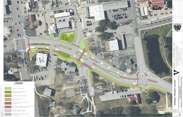
CM Allen Parkway Reconstruction
Utility relocation construction is underway. The overall project construction will start in early summer of 2018.
The CM Allen Parkway Reconstruction project will improve the section of roadway between Hopkins Street and University Drive. The project includes:
- Street and pedestrian lighting like Downtown
- A 12-foot multi-use pathway on river side of CM Allen
- A 6-foot sidewalk on Downtown side of CM Allen
- Parallel parking along the river side
- Overhead utilities relocated below ground
- New trees and landscaping
- Bio-retention elements to treat storm water prior to entering river
- A crosswalk at Hutchinson
- Realignment of Hutchinson and river parking lots to be perpendicular to CM Allen
Coers Drive Improvements
Project Details
In 2015, the City undertook a study of the drainage runoff associated with the Old Ranch Road 12 Bike / Pedestrian and Widening project. It was determined that there will be a negligible increase in runoff associated with the road widening. Since a portion of the project drains to Coers Drive, the current drainage in this area was investigated.
The study showed that the two drainage crossings on Coers could be improved if replaced with larger pipes and the existing ditch could be enhanced to help alleviate some drainage problems in the area.
Improvements
The project will provide storm drain improvements, install 943 linear feet of box culverts, add a water quality feature, replace 1,170 feet of wastewater main and 1,050 feet of water main on Coers Drive, from Old Ranch Road 12 to Owens Street. The scope also includes the design of approximately 1,050 feet of 5 foot sidewalks.
Construction is expected to start in 2018.
- Coers-Road
- Coers-Utilites
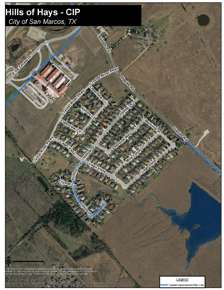
Hills of Hays Drainage Improvements
Hills of Hays Drainage Improvements project will address drainage issues the were first identified in the City’s Master Drainage Plan. Phase I of the project is underway and will evaluate existing conditions and develop recommendations to alleviate local flooding. Phase II, beginning in the Fall of 2018, will design the construction plan.
Hopkins Street – Bishop to Moore Improvements
Design Process
The City of San Marcos is in the design process to reconstruct Hopkins Street between Moore and Bishop Streets, and to identify ways to improve drainage in the neighborhood.
Approach
A “Complete Street” approach will be used in the design of Hopkins Street, with considerations to:
- Existing heritage trees
- Pedestrian and bicycle traffic
- Streetscape and gateway elements to enhance the historic neighborhood
- Traffic calming
- Utility considerations
Drainage
Drainage in the neighborhood will be analyzed to determine needed upgrades in the system.
Useful Documents
- Council Presentation 2015 (PDF)
- February 11 2016 Public Meeting Presentation (PDF)
- Hopkins Presentation for July 29 2015 (PDF)
- Public Meeting Exhibits (PDF)
- Survey Results (PDF)
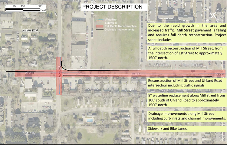
Mill Street Reconstruction
The Mill Street Reconstruction Project includes:
- A full depth reconstruction of Mill Street; from the intersection of 1st Street to approximately 1500’ north
- Reconstruction of Mill Street and Uhland Road intersection including traffic signals
- Sidewalks and bike lanes
- 8” waterline replacement along Mill Street from 100’ south of Uhland Road to approximately 1500’ north
- Drainage improvements along Mill Street including curb inlets and channel improvements
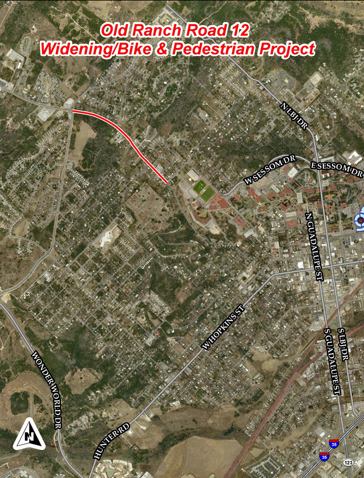
Old RR12 Bike / Pedestrian & Widening
Background & Schedule
- 2010 – CAMPO awarded Funds to the City
- Federal government reimburses the City $99,000 with a local match of match of $101,000
- Build bike and pedestrian improvements along Old Ranch Road 12 from Hughson to Holland
- 2013 – Scope was expanded and preliminary engineering report completed
- Extended limits; revised limits where changed to Craddock to Holland
- Road widening added
- Water and wastewater scope added
- Water Quality/Lid features added
- 2015 – Bike lane survey concluded and drainage investigation complete
- 2017 – Project delayed at the request of City Council to make funds available for needed drainage projects
Schedule
- 2022 – Start Construction
- 2024 – End Construction
Useful Documents
- Old RR12 Bike Pedestrian Widening Location Map (PDF)
- Old RR12-Summary Of Comments2 (PDF)
- Old RR12-Summary Of Survey Data For Web No Comments (PDF)
- Public Meeting Presentation(20160224) (PDF)
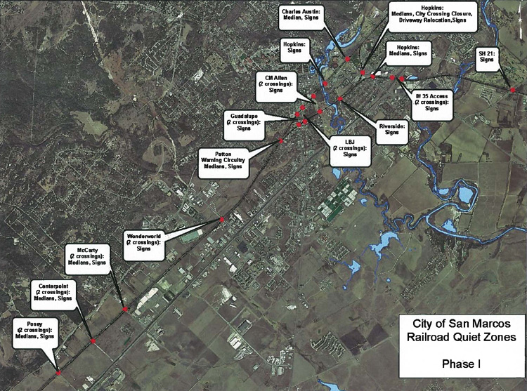
Railroad Quiet Zones Phase I
Project Overview
The City of San Marcos has been working on a project to create “Railroad Quiet Zones” at 19 public crossings in San Marcos. Currently, there are over 30 trains per day moving through San Marcos. A reduction in the noise of the trains, especially during the night, will have a positive effect on the quality of life for our citizens.
Quiet
When a railroad zone goes ‘quiet,’ trains are prohibited from using their horns to announce their approach to an intersection unless the conductor sees an obstruction on the tracks or perceives a hazardous situation. Although the intersection improvements will meet federal safety thresholds, motorists will always need to use caution when they cross railroad tracks and obey crossing signs.
Upgrades
In 2013 city crews began a project to upgrade streets that intersect with railroad tracks. The upgrades included:
- The “Ajax” Connector from Hopkins Street to Aquarena Springs Drive
- Adding “No Train Horn” signs
- The Austin-Line 1 track from Posey Road to Charles Austin Drive
- The Austin-Line 2 Track from Posey Road to SH 21
- Building medians at crossings for traffic control and to prevent vehicles from going around crossing gates
- Phase One includes three quiet zones:
- Union Pacific installation of quad gates and constant warning rail circuitry at the Patton Street crossing to detect the approach of trains and to lower and raise crossing gates; other crossings already have this technology
Phase One
In all, 19 intersections were improved in Phase One. Half of the intersection improvements only needed new signs. Street medians were installed at Posey Road, Centerpoint Road, McCarty Lane, Charles Austin Drive, and two intersections on Hopkins Street. The medians prevent motorists from driving around lowered crossing gates.
Phase Two
Phase Two of the project will be the improvement of the Post Road and Uhland Road crossings and will be completed after the scheduled improvements are made to Loop 82 (Aquarena Springs Overpass).
Useful Documents
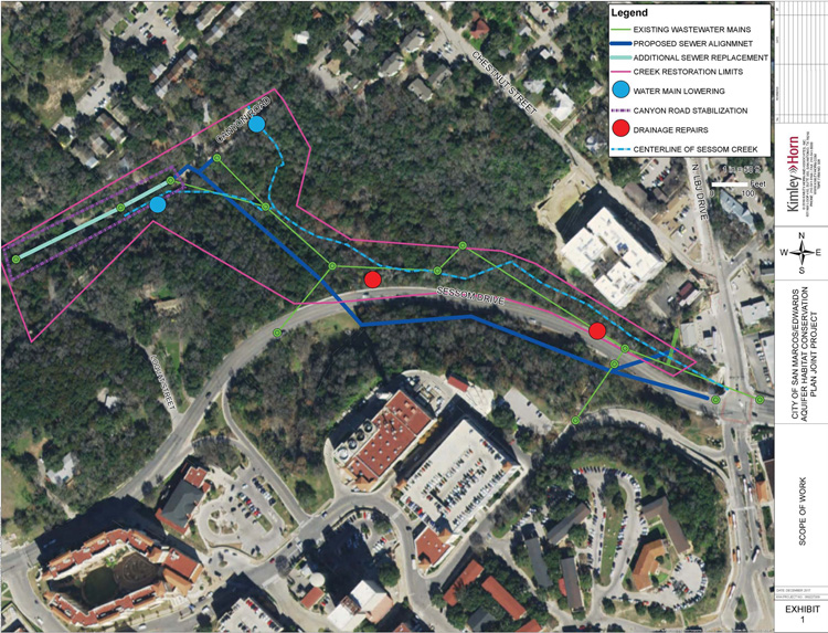
Sessom Creek Improvements Phase 1
In 2013, the City hired RPS Espey to evaluate Sessom Creek from Canyon Road to Aquarena Springs Drive. In this report, RPS Espey identified several conceptual level solutions. The highest priority project, according to this report, is to relocate the exposed wastewater trunk main in Sessom Creek from N.LBJ to Canyon Road.
The project consists of the following improvements:
- Sessom Drive Sanitary Sewer – the replacement of up to approximately 1,800 linear feet of 12-inch sanitary sewer line from N. LBJ Drive to Canyon Road along Sessom Drive.
- Canyon Road Water Line Relocation – the lowering of up to 60 linear feet of 12- and 12-inch water lines currently exposed within Sessom Creek.
- Sessom Creek Restoration Project: Project Survey and Coordination – The Sessom Creek Restoration Project will be designed by John Gleason, LLC in a separate contract with the Edwards Aquifer Habit Conversation Plan (HCP). However, Kimley-Horn will provide topographic survey for the design.
In addition to the wastewater replacement, this project originally included the repair of two (2) drainage sites, repair of damaged sections of Canyon Road, and stabilizing two (2) water main crossings. When the HCP learned about the City’s wastewater project, they asked if the City would consider stabilizing Sessom
Creek within the limits of the wastewater project. City staff agreed if the HCP paid for the additional design and construction. The HCP also agreed to incorporate the non-wastewater improvements into their design if the City will contribute the previously budgeted funds of $500,000 towards the Sessom Creek Restoration project.
The City and HCP agreed upon this final scope for the Creek Restoration Project:
- Stabilizing Sessom Creek from N.LBJ to Canyon Road to prevent sedimentation from entering the San Marcos River
- Repairing two (2) separate drainage outfalls along Sessom Drive and Sessom Creek
- Repair sections of Canyon Road that have been damaged by Sessom Creek
The HCP has budgeted $1.5 million towards the Creek Restoration Project. They City has budgeted $500,000 towards the Creek Restoration Project and $2.2 million towards the Sessom Creek Wastewater Replacement.
Both the Sessom Creek Wastewater Replacement Project and the Sessom Creek Restoration Project will be combined and bid under one contract.
Construction should occur in 2019.
Project Exhibits
- Loquat Road Alternatives
- Sessom Creek Improvements Project Overview
- Sessom Creek Restoration-Project Overview
- Sanitary Sewer Plan Profile Exhibit
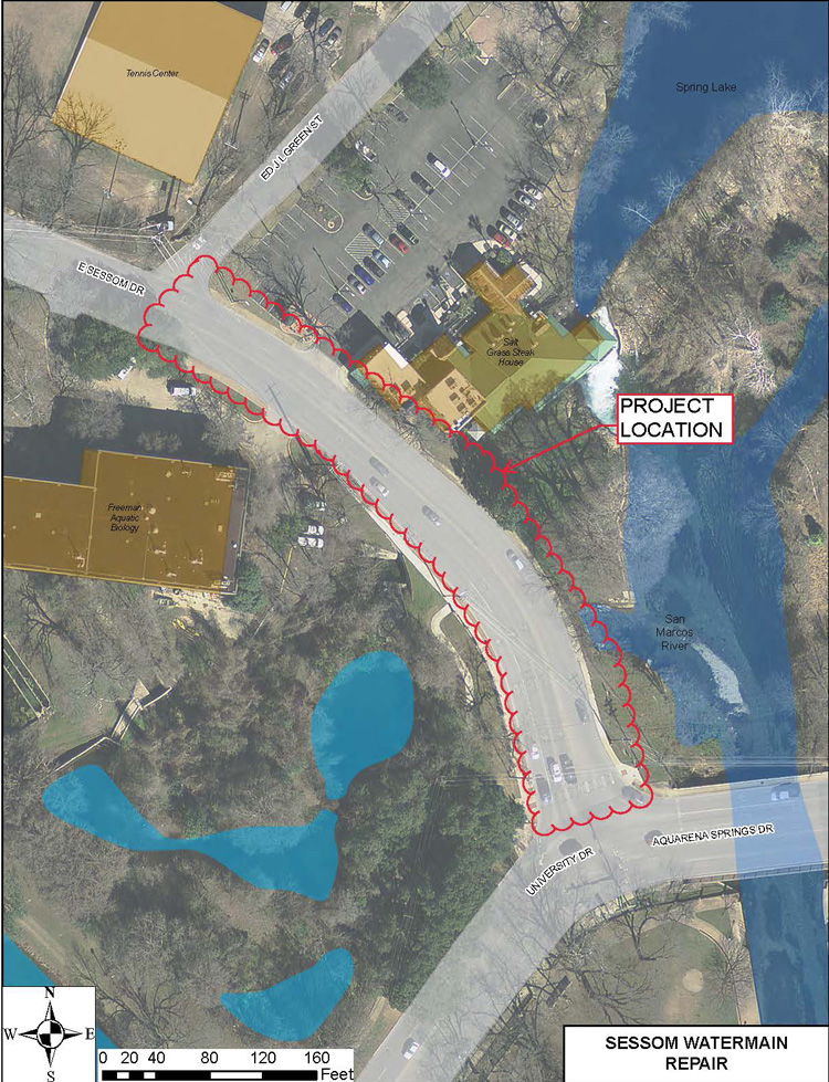
Sessom Waterline Repair
A section of 12-inch waterline under Sessom Drive between Ed JL Green and Aquarena Springs ruptured in November 2017. The rupture occurred where this line currently passes through a box culvert just south of the Salt Grass Restaurant.
This project will provide an engineering design to replace that section of waterline between the stated roads. This section of waterline together with other connected segments are past their useful service life and have suffered several breaks in recent years.
Total project cost is estimated at $300,000 with design scheduled to start in January 2018 and construction starting in the fall of 2018.
Sewer System Evaluation Studies (SSES)
SSSES for Edwards Aquifer Recharge Zone Repairs
This project will repair wastewater mains at five areas in the City that are within the Edwards Aquifer Recharge Zone. The existing sewer mains slated for repair have been deemed defective and have the potential to negatively impact the environment.
Specifically the project locations are in these areas:
- Bert Brown from the River to Post Road
- Brown Street from Clara Street to Greenpointe
- Craddock Avenue between Furman Avenue and Indiana St.
- Dale Dr. between Girard St and Furman Avenue.
- Furman Avenue from Craddock to Dale Dr.
- Girard St, from Craddock to Dale Dr.
- Indiana Street from Craddock to Hamilton Street
- Nevada Street between Castle Creek Drive and Castle Gate Circle
- Veramendi Street
Costs
Estimated Construction cost is $2.4 million and construction is expected to begin in early 2018.
Travis St/Heritage Drainage Outfall Improvements
This project will construct a drainage system from the Hopkins and Travis Street intersection and outfall into Purgatory Creek in the Dunbar Park area. The design will include water quality treatment opportunities prior to discharging into Purgatory Creek. The project will alleviate drainage issues and accommodate the improvements of the future Hopkins Street – Bishop to Moore Improvements project.
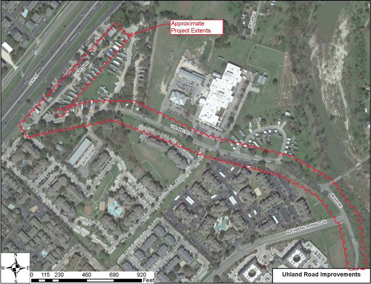
Uhland Road Improvements
This project is funded through HUD’s Community Development Block Grant Disaster Recovery Program (CDBG-DR) funds following the 2015 flood events. The project will improve drainage and mobility along Uhland Road during rain events.
The project includes:
– The reconstruction of County Road and Uhland Road between IH-35 and approximately 200ft south of the Aquarena Springs Dr. intersection.
– Stormwater drainage system along County and Uhland Roads with an outfall to the Blanco River.
– Sidewalk extension along Uhland Road to Aquarena Springs Drive.
– Water and wastewater improvements along Uhland Road.
– Uhland Road and River Road intersection improvements.
Total project cost estimated at $4.2M. Design started in September 2017. Construction anticipated to begin in summer 2019.
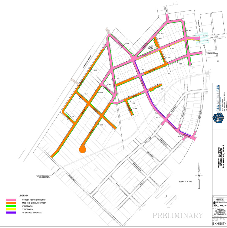
Victory Gardens Neighborhood Improvements Phase I
Project Description
Reconstruct streets, drainage, water and wastewater systems in the Victory Gardens Subdivision to improve reliability of service to approximately 350 residential customers.
North Reconstruction
Alabama, Arizona, Armstrong, Camacho, Churchill, Eisenhower, Georgia, Gomez, Hull, MacArthur, Patton Railroad, Rodriguez, Roosevelt, Truman, Virginia and Wavell are to be reconstructed in the North Section.
Useful Documents
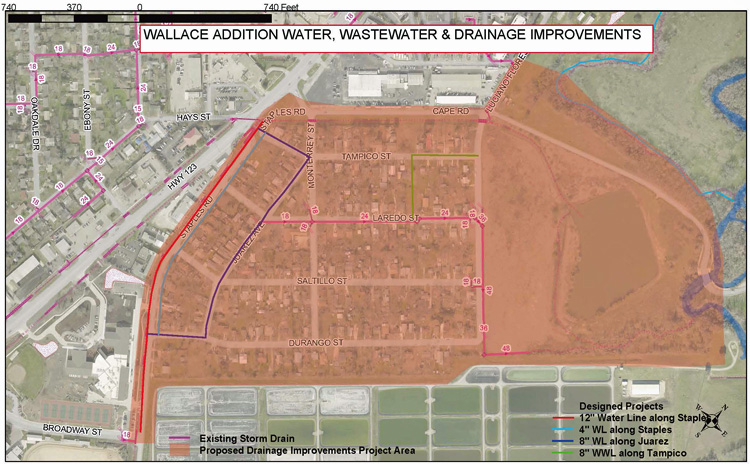
Wallace Addition Water, Wastewater and Drainage Improvements
Project Details
Initially a water and wastewater improvements project, the Wallace Addition Improvements scope has been revised to include drainage improvements in the neighborhood and along Staples Road.
The aging water and wastewater lines in the neighborhood were identified for replacement to fulfill the City Council goal of maintaining and improving the City’s infrastructure. The water and wastewater improvements will include a 12” waterline replacement and a 4” water service line along Staples Road; an 8” water line replacement along Durango Street, Juarez Avenue and Tampico Street; and an 8” wastewater line replacement from Laredo Street to Tampico Street and Luciano Flores Boulevard.
But recently residents in the Wallace Addition Neighborhood and the Bonham Prekindergarten School have reported flooding issues. Storm water is overtopping an existing culvert at Staples Road and Broadway Street.
To address these complaints the project has been revised to include the water, wastewater and drainage improvements be constructed at the same time.
Revised schedule is as follows:
Design Completion: July 2019
Bidding: January 2020
Construction Completion: October 2020
![]()
The following projects are listed above, however no additional information is available
- Clarewood Drainage Area Improvements
- Cottonwood Creek 24 inch Waterline
- Hopkins Multi-Use Path
- Hutchison Water Quality Pond Repair
- IH 35 Utility Relocation
- Old Bastrop Road – Rattler to Centerpoint
- Primrose Way Waterlin
- Reclaimed Water Expansion – Elevated Storage Tank
- Reclaimed Water Expansion – Pump Station Upgrades
- Red Sky Water Main
- River Road Pavement and Bank Stabilization Project
- UPRR Pedestrian Chicane
- Wonder World Dr/Hunter Rd Intersection Improvements


